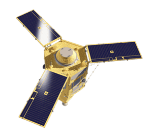
GeoEye-1
Ideal for large-scale mapping projects, GeoEye-1 provides highly detailed imagery at .46-meter panchromatic and 1.84-meter multispectral resolutions. It can geolocate features to less than 5m, offers stereoscopic collection on a single pass, and can revisit any point on Earth once every three days.
Very High Resolution
Industry-leading geolocation accuracy
High capacity over a broad range of collection types
Direct downlink to customer sites available
Frequent visits at high resolution
GeoEye-1 Specs
Sensor type
Optical
Resolution
Panchromatic: 46 cm
Multispectral: 1.84 m
Swath width
15.3 km at nadir
Bands
Panchromatic: 450-800 nm
Blue: 450-510 nm
Green: 510-580 nm
Red: 655-690 nm
Near-IR: 780-920 nm
Orbit
Altitude: 681 km
Type: Sun-synchronous
Acquisition
Mono, stereo
Accuracy
< 5m CE90


Unsure if GeoEye-1 is right for your project?
You shouldn’t have to be an expert in high-resolution satellite imagery to find what you need.
Our team is dedicated to making the process easy for you. All you have to do is tell us the problem. We find the answers from a vendor-agnostic perspective and present you with clear, simple solutions.
Tell us the problem
Explain the situation to us on your terms. We’ll translate it into the world of Satellite Imagery.
Review Your Options
Be presented with a simple choice of the top 2-3 imagery solutions for your project.
Make confident decisions
Know you have the right data in hand to make the critical decisions that keep your project moving forward.