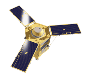
WorldView-1
WorldView-1’s high-capacity panchromatic imaging system features state-of-the-art geolocation accuracy, rapid targeting, and efficient in-track stereo collection.
- Very High Resolution
- High contrast (MTF) and signal-tonoise ratio
- Frequent revisits at high resolution
- Industry-leading geolocation accuracy
- Bi-directional scanning
- Ultra-stable platform, highprecision attitude sensors and GPS


About WorldView-1
WorldView-1, launched September 2007, is the first of our next-generation satellites—the most agile satellites ever flown commercially. The highcapacity, panchromatic imaging system features half-meter resolution imagery. Operating at an altitude of 496 km, WorldView-1 has an average revisit time of 1.7 days and is capable of collecting over one million sq km per day of half-meter imagery. The satellite is also equipped with state-of-theart geolocation accuracy capabilities and exhibits stunning agility with rapid targeting and efficient in-track stereo collection. WorldView-1 resides in a descending node of 1:30pm.
WorldView-1 Samples
WorldView-1 Specs
- Launch Information
Date: September 18, 2007
Launch Vehicle: Delta 7920 (9 strap-ons)
Launch Site: Vandenberg Air Force Base, California
- Orbit
Altitude: 496 km
Type: Sun synchronous
Period: 95 min.
- Spacecraft Size, Mass and Power
3.6 m (12 ft) tall x 2.5 m (8 ft) across
7.1 m (23 ft) across the deployed solar arrays
2290 kg (5038 lbs)
3.2 kW solar array, 100 Ahr battery
- Sensor Bands
Panchromatic: 400-900 nm
- Sensor Resolution
50 cm Ground Sample Distance (GSD) at nadir
55 cm GSD at 20° off-nadir
- Dynamic Range
11-bits per pixel
- Swath Width
17.7 km at nadir
- Attitude Determination & Control
3-axis stabilized
Actuators: Control Moment Gyros (CMGs)
Sensors: Star trackers, solid state IRU, GPS
- Pointing Accuracy & Knowledge
Accuracy: <500 m at image start and stop
Knowledge: Supports geolocation accuracy below
- Retargeting Agility
Time to Slew 200 km: 10 sec
- Onboard Storage
2199 Gb solid state with EDAC
- Communications
Image and Ancillary Data: 800 Mbps X-band
Housekeeping: 4, 16 or 32 kbps realtime, 524
kbps stored, X-band
Command: 2 or 64 kbps S-band
- Max Contiguous Area Collected in a Single Pass (30° off-nadir)
Mono: 111 x 112 km (6 strips)
Stereo: 51 x 112 km (3 pairs)
- Revisit Frequency (at 40°N Latitude)
1.7 days at 1 m GSD or less
5.4 days at 20° off-nadir or less (0.55 m GSD)
-
Geolocation
Accuracy (CE90)
Demonstrated <4.0 m CE90 without ground control
- Capacity
Capacity 1.3 million sq km per day
Unsure if WorldView-1 is right for your project?
You shouldn’t have to be an expert in high-resolution satellite imagery to find what you need.
Our team is dedicated to making the process easy for you. All you have to do is tell us the problem. We find the answers from a vendor-agnostic perspective and present you with clear, simple solutions.
1. Tell us the Problem
Explain the situation to us on your terms. We’ll translate it into the world of Satellite Imagery.
2. Review Your Options
Be presented with a simple choice of the top 2-3 imagery solutions for your project.
3. Make confident decisions
Know you have the right data in hand to make the critical decisions that keep your project moving forward.
Other Satellites
- MAXAR
- MAXAR