
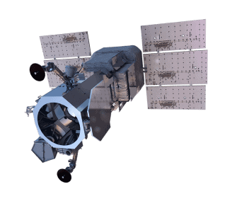
WorldView-1
WorldView-1’s high-capacity panchromatic imaging system features state-of-the-art geolocation accuracy, rapid targeting, and efficient in-track stereo collection.
Very High Resolution
High contrast (MTF) and signal-tonoise ratio
Frequent revisits at high resolution
Industry-leading geolocation accuracy
Bi-directional scanning
Ultra-stable platform, highprecision attitude sensors and GPS

WorldView-1 Specs

Launch Information
Date: September 18, 2007
Launch Vehicle: Delta 7920 (9 strap-ons)
Launch Site: Vandenberg Air Force Base, California

Orbit
Altitude: 496 km
Type: Sun synchronous
Period: 95 min.

Spacecraft Size, Mass and Power
3.6 m (12 ft) tall x 2.5 m (8 ft) across
7.1 m (23 ft) across the deployed solar arrays
2290 kg (5038 lbs)
3.2 kW solar array, 100 Ahr battery

Sensor Bands
Panchromatic: 400-900 nm

Sensor Resolution
50 cm Ground Sample Distance (GSD) at nadir
55 cm GSD at 20° off-nadir

Dynamic Range
11-bits per pixel

Swath Width
17.7 km at nadir

Attitude Determination & Control
3-axis stabilized
Actuators: Control Moment Gyros (CMGs)
Sensors: Star trackers, solid state IRU, GPS

Pointing Accuracy & Knowledge
Accuracy: <500 m at image start and stop
Knowledge: Supports geolocation accuracy below

Retargeting Agility
Time to slew 200 km: 10 sec

Onboard Storage
2199 GB solid state with EDAC

Communications
Image and Ancillary Data: 800 Mbps X-band
Housekeeping: 4, 16 or 32 kbps realtime, 524
kbps stored, X-band
Command: 2 or 64 kbps S-band
Max Contiguous Area Collected in a Single Pass (30° off-nadir)
Mono: 111 x 112 km (6 strips)
Stereo: 51 x 112 km (3 pairs)

Revisit Frequency (at 40°N Latitude)
1.7 days at 1 m GSD or less
5.4 days at 20° off-nadir or less (0.55 m GSD)

Geolocation
Accuracy (CE90)
Demonstrated <4.0 m CE90 without ground control

Capacity
1.3 million sq km per day
Unsure if
WorldView-1 is right
for your project?
You shouldn’t have to be an expert in high-resolution satellite imagery to find what you need.
Our team is dedicated to making the process easy for you. All you have to do is tell us the problem. We find the answers from a vendor-agnostic perspective and present you with clear, simple solutions.
Tell us the problem
Explain the situation to us on your terms. We’ll translate it into the world of Satellite Imagery.
Review Your Options
Be presented with a simple choice of the top 2-3 imagery solutions for your project.
Make confident decisions
Know you have the right data in hand to make the critical decisions that keep your project moving forward.
Other Satellites
When we need high-resolution satellite imagery, we trust Pacgeo for their quality imagery and reliable turnaround times.
David Bluestone
Vice President of Exploration, Bluestone Resources
Ordering high-res satellite imagery through a partner agency order desk was always painful and fraught with multiple issues. Dealing directly with Pacgeo allows me to bypass the aforementioned issues, while getting quick and reliable access to the data I need.
Government Employee
Government of Canada
